|

|
| |
I found myself headed for an unfamiliar part of the world, and I
wanted to do a little dirt fishing while I was there. I pulled out
some maps, found a park I had never heard of, and decided this
place looks as good as any.
But, where in this large park should I hunt? Ballfield? Tot lots?
Open fields? Trails and woods? Who knows?
I'm interested in attempting to find older silver coins, and this
article is a tutorial on using image overlay in Google
Earth, along with old aerial photos, in an attempt to increase one's
odds of success. The general idea is to find areas on the old
aerial photos where people may have gathered that are no longer
obvious today, overlay the old photo onto the modern photo, and
then detect that part of the park.
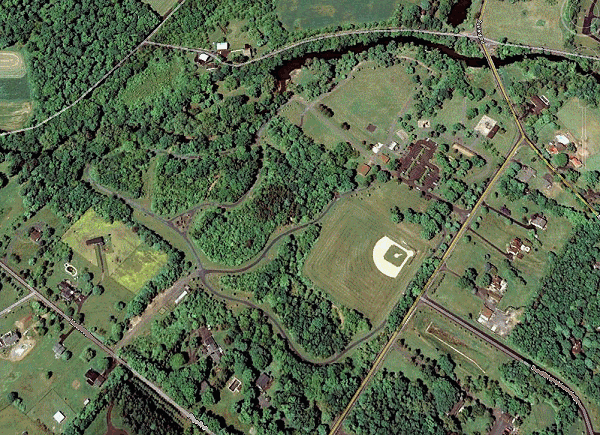
Google Earth is awesome package that gives you a modern aerial view,
and can be downloaded here. Its pretty easy to
use -- navigate to the aerial view of the park to detect, and zoom
in to the level of detail so you can see parts of the park that
look good. The above shot of the park is is from Google Earth,
and is our starting point for the tutorial. We are going to use
image overlay to try to find a good place to detect.
Historical Aerial Photos or Old Maps
Google Earth's aerial imagery only goes back to 1994. The goal here
is to go back as far as possible. If you are looking for silver coins,
you obviously have to go back to at least 1964.
Fortunately, for Pennsylvania locations like this example, there
are three sets of aerial photos available, covering the entire state.
One set is from 1937-1942, one is from 1957-1962, and one is from 1967-1972.
I don't know what is available for other states, but I understand
Historic Aerials has
a few. Poke around the web. If you can't find aerial photos, antique
maps that show the location of old buildings and so forth will work
just as well for the purpose of this tutorial, so long as they are
about the same scale as the modern image.
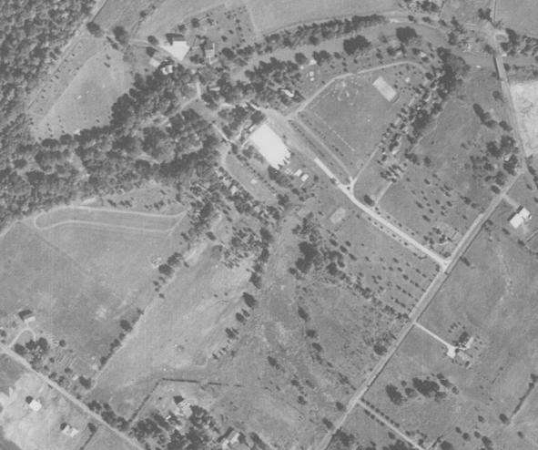
In any case, find the old aerial or map of the same area that
you wish to overlay. For
Pennsylvania, I use Penn Pilot,
and for this example,
used a aerial from 1958. That should give us a decent chance to find
some silver coins if we can find a good area on the photo that isn't
obvious today, and thus not already hunted to death.
This step can be surprisingly tricky. It can be difficult to find
the same place on the historical aerial as on the modern view. The
trick is to look for things that haven't changed, like obvious lakes,
rivers, railroads, and certain roads. Be careful, however, as roads
sometimes are re-routed. Download the historical aerial into a
photo editing program like Photoshop, and crop it to about the same size
and area as the area of interest, as in the example below. It doesn't
have to be exact, but the closer, the better.
| |
|
|
You can see in the historical some of the features that were there 50
years ago, and try to make a guess as to where people would have been.
I can think of a few ideas. You can also see that the modern ballfield
and some parts to the west seemed less likely to have traffic back then,
and thus less likely to have older coins.
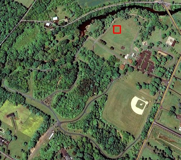
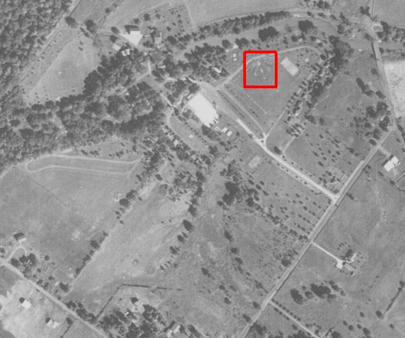
The feature that leapt out at me was the old ballfield, quite
far from the modern one, indicated below, and not visible on the modern
aerial at all. Experience tells us that people are always losing stuff
at ballfields; perhaps it was the same back then. Experience also seems
to tell me that the best place to hunt ballfields is along the first
base line. Since finding old deep silver requires taking a smallish
area and really concentrating on it slowly, for this example we will try to overlay the old ballfield on the modern park, and hunt the first base
line, and then move to other parts of the infield.
| |
|
|
Obviously, we could take what we have now, and just go to that area of
the park and start swinging. But, the point of this article is
Google Earth's image overlay, so we'll go thru the exercise, because
I think it is cool, and it does have some benefits. Also, in this
example, part of the path near that old ballfield has been rerouted,
and that is not obvious. Turns out that the location of the old
ballfield is farther away from the modern path than it appears.
I did this at another location without the benefit of image overlay,
and missed it by 20 feet, and never realised it until I went thru the exercise. (Its also nice to see the new path vs the old path, as right
along the side of old paths is another potential hunting idea).
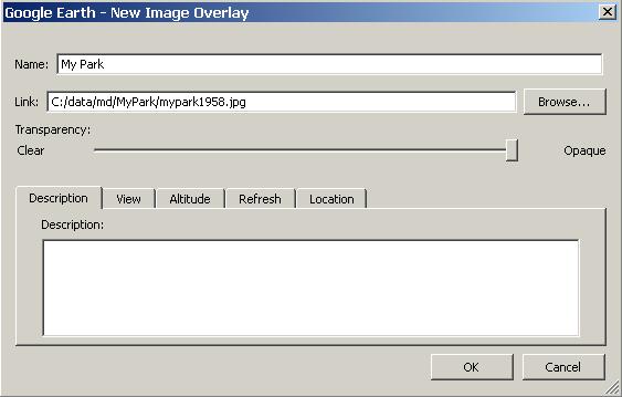
Setting Up an Image Overlay in Google Earth
The image overlay editor will come up, which is a series of green lines
and shapes (explained shortly), as well as a dialog. In the dialog,
browse to the location of the historical aerial or old map from above,
which will bring up the historical image into Google Earth (as explained
below, you can skip the browse step for now if you have a pretty good
idea of the boundaries of the historical photo).
| |
|
|
| |
|
|
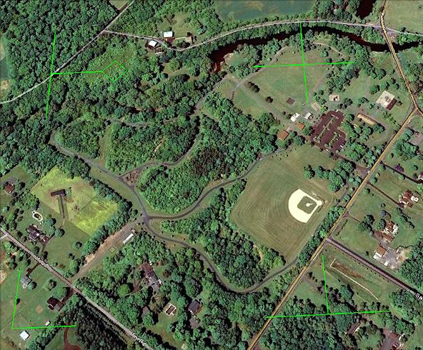
You use the green lines in the editor to line the historical image
up exactly with modern image in Google Earth. Use the corner and
T-shaped pieces on the edges to stretch or shrink the area. Use the
plus in the middle to move the whole thing. Use the diamond on the
west side to rotate the image.
You can do this either with or without the historical image loaded
via the dialog. (If you want to do it without it being loaded, and
you already browsed to the location, simply slide the "Transparency"
slider all the way to the left).
The idea is to get it as exact as possible, and
unless you managed to get the thing the exact size when you created
it, you will probably have to stretch and shrink a little bit. Use
the permanent features in the terrain to fit it exactly; in this
case, the river
to the north, and the bounding roads. You know these are more likely
to not have changed -- you can't rely on park features as much, in
this case, the one path has moved a bit, and a building has been
torn down. Below you can see where the green lines had to be moved
to make the images line up.
| |
|
|
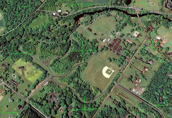
Once you are satisfied that it is lined up as close as possible,
enter a name for this overlay in the dialog, and click "OK". This
will now be a part of your Google Earth database for future
reference, as you can see on the right.
I think this is really cool, and if you are like me, you will want
to come up with a systematic way to name these. You enable/disable
them on the map with a checkmark, and you can bring back its dialog
(mainly to change the transparency), by Right Click -> Properties
on the particular image overlay you are interested in (in this case,
"MyPark").
By sliding the transparency slider back and forth,
we get an idea of
exactly where the infield of the old ballfield was, and can mark that
on the modern map, and go out and find some silver. (Note: the blueish
dots are artefacts of the animation, and not mysterious 50 year old blue
bushes. The animated png look normal, but it is way to big. This is
really cool in the actual Google Earth application. Try it!).
Well, it went ok. Found one silver and a handful of wheaties along the
infield (three on the first base line, one near home plate). All
were deep, 6-8 inches. As a test, I hunted other areas of
the park for about the same amount of time, and only found one wheatie.
Not very scientific, but I think it is cool, so I put up the article
anyway. The one thing that was nice was that I had the confidence to
spend time at this particular spot in the field because I knew there
was something significant in that exact spot in the olden days. That
patience and confidence is important when hunting the deep silver.
If you found this article helpful, feel free to consider a tip (in which case I'll tell you where the park is if you
want to know :-))
|
| |
|
|
| |
|

|
| |
|
|
|